 by
by Last Updated on 28/11/2025 by Claire Coney
…This morning we planned to explore the dog-friendly St Anthony’s Head Walk with our Cairn Terrier, Abigail. We wanted to explore the southwest coastal path and visit St Anthony’s Lighthouse.

This post contains affiliate links. If you use these links to buy something we may earn a commission. Thanks
Austin and I were up before the sunrise and it was chilly. The hill behind our camping spot prevented the sun from warming us. Austin made hot drinks while I tied the van and set it back to day mode. Then we sat in our cosy camping chairs beside the van. Abigail was still in the van, asleep on her travel mat, covered with her fleece blanket keeping her cozy. Austin drank his coffee and I drank my tea. During this time, we watched the sun climb above the hill. It was a pleasure to feel the warmth when the sun greeted us with its glorious rays.
Austin packed our daysacks with everything that we would need for the day. A scrumptious picnic and plenty of water is an essential part of the trip. Hands up who doesn’t love a picnic?
Now that the sun was up and warming the day, I got Abigal out of her bed. I put on her dog car harness and attached her to the safety restraint. Now we are ready for our dog-friendly St Anthony’s Head Walk
Planning for St Anthony’s Head Walk with Your Dog
Make sure you’re ready for a good, safe walk. Put on comfy walking boots because it can get muddy if it rains. Remember to take water for you and your furry friend. If you want to rest, think about having a picnic. Keep your dog on a leash, and don’t disturb the animals around to keep the place nice. Have fun on your walk!
Stay At: Ros Cottage, Roseland Peninsula, Cornwall
The National Car Park – Porth
We headed off along the Roseland peninsula for our dog-friendly St Anthony’s head walk. Soon we arrived at the National Trust car park at Porth. This tiny village was once a farming settlement. The 19th-century houses have been converted into tenanted and holiday cottages. The National Trust has converted a wonderful old barn into a beautiful café. You might like to treat yourself to a Cornish cream tea in the cosy courtyard when you have finished your walk…
Directions
To reach Porth Farm Car Park, located near Portscatho, Cornwall, TR2 5EX, you can follow the directions provided by Google Maps. The car park is accessible from dawn to dusk, with parking charges applicable unless you’re a National Trust member or Blue Badge holder. It’s recommended to have cash for the pay and display machines, as mobile reception can be unreliable in the area. For a detailed accessibility guide and additional visitor information, you may refer to the National Trust’s official website.
St Anthony’s Head Walk.
A spectacular 6.5-mile circular walk from the National Trust car park, Porth. The dog-freindlySt Anthony’s Head Walk has moderate to easy terrain. But there are some steep climbs up to St Anthony’s head. The stretch from Saint Anthony’s head lighthouse to Porthbeor beach provides easy walking. This is a well-signposted route making it easy to follow.
There are magnificent views as well as plenty of historical sites of interest. Try spotting some wildlife along the way. You can enjoy the lighthouse; you might even recognise it as it’s famous for the filming of Fraggle Rock. In addition, you will find hidden beaches at Porthbeor and Towan. These splendid beaches are dog-friendly.

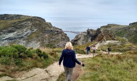
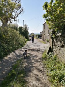
1. The Start of The Dog-Friendly St Anthony’s Head Walk
…Austin, Abigail and I set off from the small car park. Then turned immediately left. We followed the narrow lane past the charming holiday cottages. Shortly the route divided and we took the left fork along a gravel path…
(Alternate route – right fork – takes you to the quay where you can take the foot ferry to St Mawes. The path then continues to St Anthony’s lighthouse.)
…The flower-lined path climbed gently and their fragrance was thick in the air. We could see glimpses of the Percuil’s Creeks below. Through the hedges, I could see the yachts and small boats anchored at moorings. It was so peaceful the only noise I could hear was bird songs.
Before long another signpost directed us left across open fields. It meandered along the hedgerows and the view of the sea was spectacular. The route met a track that took us to Bohortha, a tiny hamlet…
Hamlet of Bohortha
Formally known as St Anthony’s Village, but it was renamed after one of the farms that existed here until the 1970s. It was one of 3 farms. The others were Manor Farm and Boharrow Farm. In times gone by the hamlet had a pub and a school for the local children. Sadly, this closed in the 20th century.
2. Continue The Dog-Friendly St Anthony’s Head Walk…
…The route turned right taking a track out of the hamlet. In a short distance, a signpost directed us left into a field. It had amazing sea views and a farm in the valley below. We followed the path along the edge of the grassy field. In the corner of the field, the path popped through a hedge into dark, shady woodland. The musty smells from the woodland wafted towards me. I carefully made my way down some steep stone steps and Austin held out his hand to help me down to the road.
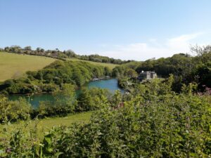
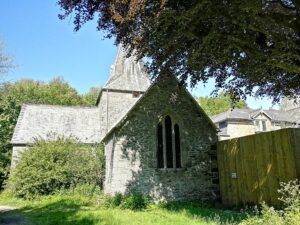
Across the road, the shadowy woodland path meandered along to St Anthony’s Church. The church was in a pool of sunlight making it stand out from the dark shady graveyard. It was beautiful…
St Anthony’s Church
The church was built in 1150 when the Augustinian Priory of Plympton owed most of the land in the area. The church has a Norman doorway which came from Pimpton by boat. The Spry Family renovated the church in the 19th century. They preserved the church’s original medieval cruciform plan in the process.
Place House is next to the church and stands on the original site of the priory. It was once a tidal mill. Then the Spry family turned it into a house in 1851. It was rebuilt in the French Chateau style and reused many of the beams and doors from the mill.
The pretty cottages at the mouth of Place Creek were once used as Pilchard Cellars. The fisherman caught the fish and proceeded to them. Then they shipped the fish to France.
3. Continue The The Dog-Friendly St Anthony’s Head Walk…
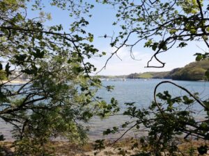
…The woodland path continued in dappled sunlight. It followed the Place Creek until it met the River Percuil. The view along the Creek and river was stunning. Through the trees, I could see lots of small boats and yachts at their moorings. The water was bright blue against the darkness of the trees. We continued along the shady path through a nature reserve…
Wildlife
The nature reserve and estuary are great places for spotting birds. There are two species of diving duck to look out for, the Goldeneye and Red-breasted Merganser. You could also spot Great Northern and red-throat divers or Grebes. Near the lighthouse, there’s a bird hide where you can observe a Colony of Fulmars gliding on the sea breeze. You might also see Gannets feeding offshore. As well as Shaggs and Cormorants on the rocks by the lighthouse.
The waters are rich in wildlife too. It is home to cuttlefish, seahorses, sea slugs and sea anemones. It is also the home to eelgrass, Briton’s only flowering marine plant.

4. Continue The Dog-Friendly St Anthony’s Head Walk…
…The cool wooded path finally opened into a wide green pasture at the top of the hill. We descended the slope and walked along the top of the Cliff.
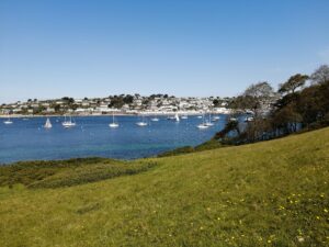
The views along the Cliff were spectacular. We could see St Mawes and its sheltered harbour. St Mawes Castle stood proud on the hill above the town. The clear waters of the bay sparkled in the sunlight. Beautiful sandy beaches lay at the bottom of the Cliff.
Groups of families sat together on the sand and we watched as they played on the beach. The river mouth was full of different boats darting this way and that. The noise from the boats and the people chattering drifted up the Cliff.
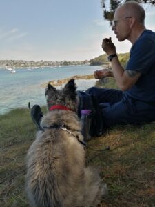
By now the day had grown hot so we decided to take a break. We sat under some tall fragrant cedar trees. Abigail was ready for some water. She sat patiently waiting for Austin to produce her water bottle and travel bowl from the backpack. We sat for a while and watched the boats on the water. It was a pleasure to be able to sit and absorb our surroundings.
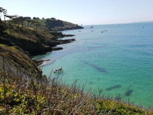
We set off again, along the South West coastal path. Now distant views of Saint Anthony’s lighthouse unfolded ahead. I could also see small boats in the bays below. The people from the boats had come to the coves with picnics for their family.
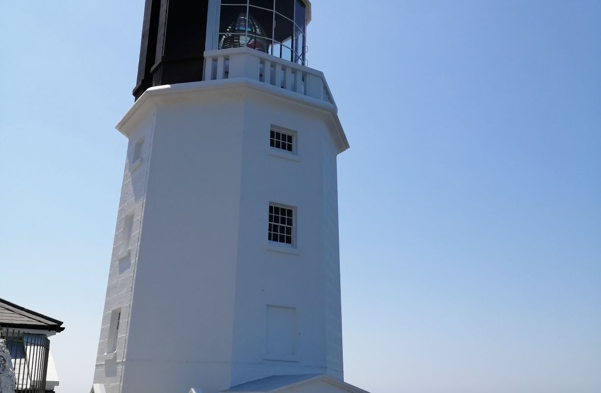
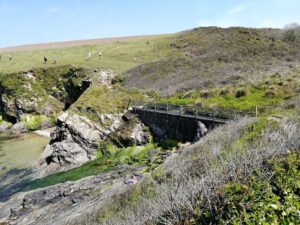
Autin and I crossed a small wooden bridge and took the right fork ignoring the steep steps ahead. We soon rounded the headland and found St Anthony’s Lighthouse. We stop to admire the striking building…
The Lighthouse
The National Trust has restored the lighthouse to its former glory. They have turned it into luxury holiday accommodation. But, it was originally built in 1835 to warn ships of the Manacles rock to the south of Falmouth harbour.
In the 17th century, the Killigrew family flew a big red flag from an elm tree. This allowed the ships out at sea to know the wind direction in the bay. However, the flag was removed in 1779 so that invading fleets of ships could not use it.
In 1864, Trinity House erected a beacon powered by 8 oil lamps. Polished metal reflected the light out to sea. The lighthouse also had a massive bell up until 1954 which rang out on foggy days. Later electricity came to the lighthouse and a foghorn replaced the bell. St Anthony’s lighthouse was fully automated in 1987.
The Lighthouse is 19 metres high and 22 metres above the sea at high tide. Its red and white lights flash every 15 seconds. Ships can see the white light for 16 nautical miles out to sea. And ships can see the red light for 16 nautical miles out to sea. In addition, the fog horn gives a 3-second blast every 30 seconds.
…We retraced our steps until we reached the fork in the footpath. Then we took the right path up the hill. Shortly we came to St Anthony’s Battery – the remains of a 19th-century gun emplacement…

The Battery
There has been a signal station at St Anthony’s Head since the Iron Age. Throughout history, this area has been of strategic importance and had a fort on the site.
The first battery established in 1805, had 24-pounder guns near the lighthouse. The existing wartime complex, built in 1885, had unclimbable iron fences.
At the turn of the 20th century, a new battery was built and manned by the 105 Royal Garrison based in Falmouth. However, the Territorial Army took it over in the First World War. After the war, the guns were sent to Pendennis Castle for preservation.
At the start of the Second World War, the guns returned to the Battery. And again, the Territorial Army manned the Battery. The battery remained on standby until 1956 when it closed. Three years later The National Trust acquired the Battery. Now the Battery is accommodation for tourists.

5. Continue The Dog-Friendly St Anthony’s Head Walk…
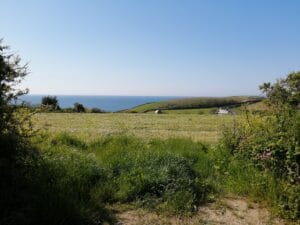
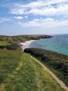
…We continued along the South West Coastal path. The route was much more rugged and it was ungulated along the wind-swept cliff tops. It crossed rolling green pastures where cows chewed on the lush grass. I could smell the faint odour of sea spray in the air. We climbed over Cornish stone styles that divided the fields. Then stopped at a beautiful stop on the cliff top for our picnic. It was a beautiful spot with the sandy Porthbeor beach below. It looked out over the sandy cove and the views along the Roseland peninsular and out to sea.
Austin pulled Abigail’s water and dog treats out of the magic bag while she waited eagerly. Our picnic was not fancy today, just fruit and protein bars to keep us going until dinner time. Once we were all satisfied, Austin closed his eyes for 40 winks. I set up a sunshade for Abigail using my waterproof jacket. She stretched out beneath the shade and joined Austin for a snooze. I sat looking out to sea daydreaming of more adventures. I enjoyed feeling the warm sun on my face and the gentle breeze that ruffled my hair.
After our break, we continued along the coastal path taking in the spectacular views. It was a short distance to Towan Beach (dog-friendly all year). It is a huge expanse of sand and the tide was out exposing rockpools.
6. Completing The Dog-Friendly St Anthony’s Head Walk…
A signpost directed us across the field. We went through a wooden gate and followed the lane a short way. Then turned off to the left and followed a lovely shady path taking us back to the car park.
Have you done the dog-friendly St Anthony’s Head Walk? Let me know in the comments.
Did you enjoy it as much as we did?
Is there anything along the route that you recommend that other people should see?
Next, we will be exploring some of the dog-friendly beaches on the Roseland peninsular. Come and join us…